|
|
| Lanai Magazine - Place of Interest, Lanai, Hawaii |
 |
| Lanai, Hawaii |
|
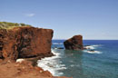
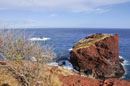
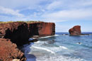
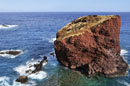
Pu'u Pehe Rock -- Sweetheart Rock |
|
|
Take Highway 440 south from Lanai City approximately 13 miles. Follow the signs to the Hulopo'e Beach Park. Take the trail to the left of the beach to the overlook.
An ancient legend tells of two lovers, a young warrior from Lanai named Makakehau and a beautiful Hawaiian girl named Puupehe from Lahaina on the island of Maui. The young warrior loved the pretty girl so much that whenever he looked at her, his eyes would mist up with tears. Hence his name Maka (eyes) and Kehau (mist).
Makakehau brought Puupehe with him to live on Lanai and hid her in a sea cave at the base of a cliff because he was afraid to lose her. One day as he was out gathering supplies, he noticed a storm brewing and headed back to the cave. There he found his Puupehe drowned by the surge of the storm waves.
He was so stricken with grief that he took his girl in his arms and cried out to the gods and his ancestors to help him climb up the steep cliff of the little rock island, where he buried her. He then jumped to his death in the powerful surf and sharp rocks below.
Even though this legend is laced with romance, archeologists who have studied the sea stack state that there are no human remains in the "tomb" at the top. They surmise that the "tomb" may actually be a bird heiau built by ancient Hawaiians. Numerous bones from sea birds are located near the heaiu.
Pu'u Pehe Rock outcropping stands 80 feet high and lies 150 feet offshore. It is surrounded by numerous smaller rocks, tidepools, and strong currents. |
|
| Lanai, Hawaii |
|
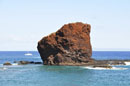
Kane'apua Rock |
|
|
Take Highway 440 west out of Lanai City toward Kaumalapau Harbor. Go past the airport turnoff and take the next left Kaupili Road, an unmarked dirt road. Travel approximately 2.5 miles to a yellow standpipe on the right. Turn right on this rocky road which descends downhill about 3 miles to Kaunolu Village. The Rock is located to the right, just off shore.
This small lava rock outcropping is located at the southern tip of Lanai near the ancient village of Kaunolu. The area is well known for its excellent fishing and small tidepools can be seen surrounding the rocks. The highest sea cliffs on Lanai are also located along this coast. Good fishing along this coast. The ocean is often very rough in this area and not good for swimming with strong currents and high surf. |
|
| Lanai, Hawaii |
|
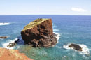
Palaoa Point |
| |
|
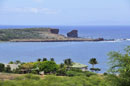
Take Highway 440 west out of Lanai City toward Kaumalapau Harbor. Go past the airport turnoff and take the next left Kaupili Road, an unmarked dirt road. Travel approximately 2.5 miles to a yellow standpipe (see last picture on this page) on the right. Turn right on this rocky road which descends downhill about 3 miles to Kaunolu Village and the point.
The southern tip of Lanai is marked by Palaoa Point. This is the site of the ancient Kaunolu Village where Hawaiians lived for thousands of years. The waters off this coast are rich for fishing and a freshwater stream flows through the nearby Kaunolu Gulch. A small sea arch is seen near the point formed by lava flowing rapidly into the sea. As the lava quickly cooled with the sea water, the rock became weak. After hundreds or thousands of years, the rock collapses and forms an arch or even a sea cave. A lighthouse stands watch over the point protecting ships from beaching themselves on the numerous reefs nearby. Good fishing. No facilities. |
|
| Lanai, Hawaii |
|
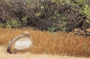
Kaumalapau Tidepools |
|
|
Take Highway 440 west from Lanai City to the end of the road. The harbor is approximately 7.5 miles out of town. The tidepools are located on the right side of the harbor.
Great tidepools can be found to the right of the Kaumalapau Harbor. These tidepools are home to many small sea creatures. This area is well-known by local fisherman as an excellent shore fishing spot and you can see fisherman lined up along the sea wall. Do not wear oil or lotions in the pool as they are lethal to the sea life that lives in the tidepools. Wear reef shoes as the lava is rough and slippery. Always use extreme caution when entering tidepools as the ocean is dangerous and unforgiving. No facilities anywhere nearby. |
|
| Lanai, Hawaii |
|
Lighthouse Ruins |
| |
|
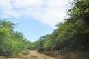
From Lanai City, take Highway 44 northeast to the end of the road (approximately 7 miles). Turn left on the dirt road and continue for 1.6 miles to the parking area near the lighthouse ruins.
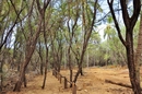
Ruins of an old lighthouse marks the trail to the shipwreck on Shipwreck Beach. Many old lighthouses have been removed from service and light beacons have replaced them. The 'Au'au Channel which divides Lanai and Maui, known for its strong currents and numerous shallow, rocky reefs. Many ships have gone aground along this channel. Park here to begin the hike down Shipwreck Beach to view the shipwreck or walk the Kaiolohia-Kahu Trail. Ancient Hawaiians lived in this area between the 15th and early 19th Century. Petroglyphs can be found on large lava rocks nearby. Many are hidden by sand and thorny kiawe bushes. No facilities here. |
|
| Lanai, Hawaii |
|
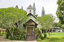
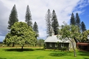
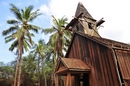
Kalokahi o Ka Malamalamo Church |
 |
|
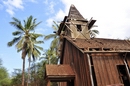
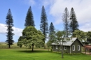
Go north out of Lanai City on Highway 44. The church is located in front of and to the left of the Lodge at Koele Resort.
This quaint little wooden church church was built during the Plantation Days of the late 1800's and early 1900's as a place for Hawaiian religious services. It is a reminder of a very different life when Lanai City was a bustling Plantation Town. Today the church still holds Sunday services spoken in Hawaiian.
|
|
| Lanai, Hawaii |
|
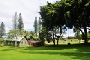
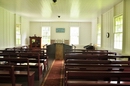
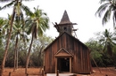
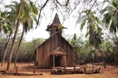
Ka Lanakila o Ka Malamalama Church |
|
|
Take Keomuku Road or route 430. Keomuku is located on the east shore of Lanai. During ancient times, fishermen and farmers settled along the coastal portions of this area up to the valley of Maunalei. Keomuku was a small and sleepy fishing village up until 1899, when the Maunalei Sugar Company moved in, turning the village into a bustling sugar plantation. It was shut down in 1901. According to a local legend, they built the railroad along the coast, damaging the sacred stones of a nearby heiau (Hawaiian temple). The Hawaiians believed that this angered the gods and that this is the reason why the sugar mill’s drinking water turned salty and the population was wiped out by an epidemic. Today, Keomuku lies abandoned and is called a ghost town by some. Little remains of the village and there is little evidence that once a thriving sugar industry was located here. The only structures that are left standing are a few old wooden houses and the original structure of the Ka Lanakila o Ka Malamalama Church, which was completed in 1903. It is the last structure that is still intact in the village. |
|
|