|
|
| Lanai Magazine - Fishing, Lanai, Hawaii |
| Lanai, Hawaii |
|
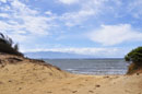
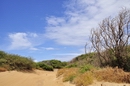
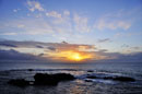
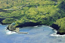
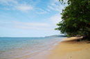
Shipwreck Beach |
 |
|
From Lanai City, take Highway 44 northeast to the end of the road (approximately 7 miles). Turn left on the dirt road and continue for 1.6 miles to the parking area near the lighthouse ruins. Shipwreck Beach lies in front of the ruins and stretches for several miles to the north and east. No lifeguards. No facilities anywhere nearby. Accessible only by 4-wheel drive vehicle, be sure to check on road conditions before starting out. |
 |
| Lanai, Hawaii |
|
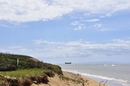
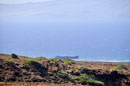
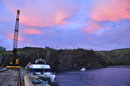
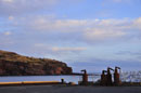
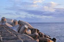
Kaumalapau Harbor |
|
|
Take Highway 440 west from Lanai City to the end of the road. The harbor is approximately 7.5 miles out of town.
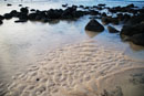
Located on the west coast of Lanai, Kaumalapau Harbor is the main harbor for the island where most fishing boats depart. The area was once a thriving and busy harbor when pineapple was king on the island. Now the harbor is quiet with only an occasional fisherman on the wharf and the Lanai Oil Company in the background. The harbor is naturally well-protected by low seacliffs. Small tidepools can be seen near the rock wall sea break during low tide. Excellent fishing spot fromt the dock as well as the nearby rock walls. Great place to watch sunset. |
|
| Lanai, Hawaii |
|
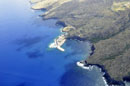
Kaunolu Bay |
 |
|
Take Highway 440 west out of Lanai City toward Kaumalapau Harbor. Go past the airport turnoff and take the next left Kaupili Road, an unmarked dirt road. Travel approximately 2.5 miles to a yellow standpipe on the right. Turn right on this rocky road which descends downhill about 3 miles to Kaunolu Village. The intrepretive hike is on the right, well marked above the bay. Frequent high surf. No facilities. |
| Lanai, Hawaii |
|
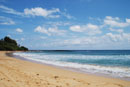
Lopa Beach |
 |
|
Take Highway 430 north out of Lanai City to the end then turn right to Keomuku Rd, follow the road to east of island. It is a long white sand beach. It begins on the south side of Kikoa Point and ends past an old fishpond, which is the most outstanding feature on this beach. The fishpond is also called Loko Lopa and has been designated as a bird sanctuary. Swimming possible when the waters are calm. No facilities. No lifeguards.
|
| Lanai, Hawaii |
|
Keomuku Beach |
 |
|
Take Highway 430 north out of Lanai City to the end then turn right to Keomuku Rd. Keomuku Beach encompasses six miles (9.6 km) of shoreline on Lanai’s east coast. Offshore is one of the longest stretches of fringing reef in Hawaii, which is more than a half mile (800 m) wide in several places.There are also remains of two ancient fishponds. Keomuku Beach is accessible with a four-wheel drive. No facilities. No lifeguards. |
| Lanai, Hawaii |
|
Kahemano Beach |
 |
|
Kahemano Beach is mainly frequented by local fishermen. The Hawaiian meaning of the name is “school (of) sharks.” The name refers to the common Hawaiian reef sharks that are often times seen here. There are all kinds of Hawaiian fish to catch. You need a four-wheel drive vehicle to access this beach, which is located on Lanai's east shore. No facilities. No lifeguards. |
| Lanai, Hawaii |
|
Naha Beach |
 |
|
Naha Beach, located on Lanai’s east coast, has one of four ancient fishponds on the island. The walls of the pond, which can be seen at high and at low tide, are the most outstanding feature of this beach. The former fishing village of Naha is located nearby. Surrounded by dirt roads. Explore the beach and come prepared with a hook and rod, since fishing is best bet here. No facilities. No lifeguards. |
|
| Lanai, Hawaii |
|
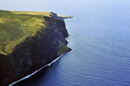
Kane'apua Rock |
|
|
Take Highway 440 west out of Lanai City toward Kaumalapau Harbor. Go past the airport turnoff and take the next left Kaupili Road, an unmarked dirt road. Travel approximately 2.5 miles to a yellow standpipe on the right. Turn right on this rocky road which descends downhill about 3 miles to Kaunolu Village. The Rock is located to the right, just off shore.
This small lava rock outcropping is located at the southern tip of Lanai near the ancient village of Kaunolu. The area is well known for its excellent fishing and small tidepools can be seen surrounding the rocks. The highest sea cliffs on Lanai are also located along this coast. Good fishing along this coast. The ocean is often very rough in this area and not good for swimming with strong currents and high surf. |
|
| Lanai, Hawaii |
|
Palaoa Point |
| |
|
Take Highway 440 west out of Lanai City toward Kaumalapau Harbor. Go past the airport turnoff and take the next left Kaupili Road, an unmarked dirt road. Travel approximately 2.5 miles to a yellow standpipe (see last picture on this page) on the right. Turn right on this rocky road which descends downhill about 3 miles to Kaunolu Village and the point.
The southern tip of Lanai is marked by Palaoa Point. This is the site of the ancient Kaunolu Village where Hawaiians lived for thousands of years. The waters off this coast are rich for fishing and a freshwater stream flows through the nearby Kaunolu Gulch. Good fishing. No facilities. |
|
|