|
|
| Lanai Magazine - Beach, Lanai, Hawaii |
| Lanai, Hawaii |
|
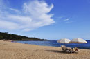
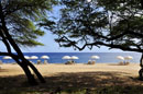
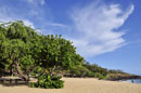
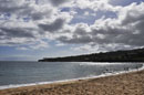
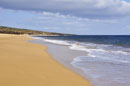
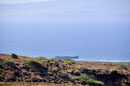
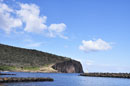
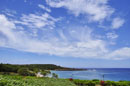
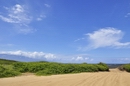
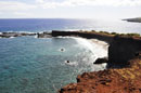
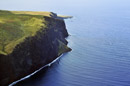
Hulopo'e Beach |
|
|
Take Highway 440 south from Lanai City approximately 13 miles. Follow the signs to the Hulopo'e Beach Park.
Hulopo'e beach is beautiful white sand beach and underwater coral formations makes it the central recrational area on Lanai. The beach is located in a protected Marine Life Conservation Area so there are numerous and colorful fish as well as unique coral formations found here. Good for swimming, snorkeling, scuba diving, and body surfing. Restroom facilities, showers, phone, picnic tables, grills, grass and shaded areas. No lifeguard. Camping allowed by permit - call 808-565-3982 for information and rates.To the left of the beach is Pu'u Pehe Rock, also known as Sweetheart Rock. Tidepools to left of the beach. Hikes and trails to left of the beach. Manele Bay Hotel located above and to the right of the beach. |
 |
| Lanai, Hawaii |
|
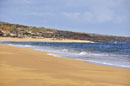
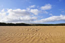
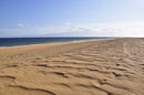
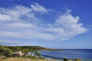
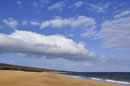
Polihua Beach |
|
|
To get to Polihua Beach, start at the Garden of the Gods and head “makai” (toward the ocean). At the trail’s end. Accessible only by four-wheel drive.
Polihua beach is over 1.5 miles long and is the longest white sand beach on Lanai. Characterized by rough waters and high winds. swimming and ocean sports are not recommended here due to the unpredictable surf and strong currents.The powerful alongshore current is always strong and will easily sweep you out to sea, even on a calm day. But on windless days, this beach is a good spot for sunbathing, picnicking and picture-taking. On a clear day, you can see across the Kalohi Channel all the way to Molokai or even to Oahu’s Diamond Head. Polihua, which means “egg nest” in the Hawaiian language, was once one of the most famous green sea turtle nesting beaches in Hawaii. But they are hardly seen here now. Whales often pass by very close to shore in the winter months. No facilities and lifeguards here.
|
|
| Lanai, Hawaii |
|
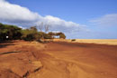
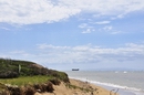
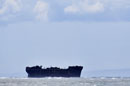
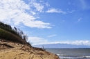
Shipwreck Beach |
|
|
From Lanai City, take Highway 44 northeast to the end of the road (approximately 7 miles). Turn left on the dirt road and continue for 1.6 miles to the parking area near the lighthouse ruins. Shipwreck Beach lies in front of the ruins and stretches for several miles to the north and east. Accessible only by 4-wheel drive vehicle. Be sure to check on road conditions before starting out.
The beach stretches over miles of northeast coast of Lanai fronting the Kalohi Channel that separates Lanai from Molokai. This channel is known for its strong currents and numerous reefs. Many a ship has run aground along this channel - thus the name, Shipwreck Beach. The World War II Liberty Ship whose hulk clings to reef close to shore. The beach is a series of sand, lava rock, and boulders. It is a great place for beach combing, swimming in this area is extremely unsafe. Great hiking. Good shore fishing. No lifeguards. No facilities anywhere nearby. Large shipwreck located approximately one mile down the beach to the left of the lighthouse ruins. Petroglyphs located near the lighthouse ruins. A entire fishing village, Federation Camp, was built from the debris washed ashore here. Kaiolohia-Kahue Trail starts from the beach. |
|
| Lanai, Hawaii |
|
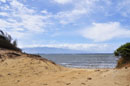
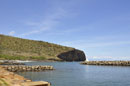
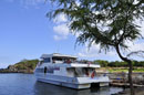
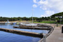
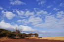
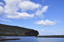
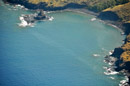
Manele Bay |
 |
|
Take Highway 440 south from Lanai City. Turn left at the end of the highway onto New Manele Road. The harbor is located at the end of this road. Approximate drive time from town is 25 minutes.
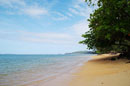
Manele Bay has Lanai's only public harbor. It’s where you arrive when you take the ferry from Maui to Lanai. Manele Bay is a marine preserve, established to protect and preserve the area’s marine resources and geological features. There is only a small white sand beach at the east end of the bay. Good for snorkeling and diving. Shade, picnic facilities, pavilion, and grills are available above the harbor area. |
|
| Lanai, Hawaii |
|
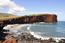
Sharks Bay |
|
|
Take Highway 440 south from Lanai City approximately 13 miles. Follow the signs to the Hulopo'e Beach Park. Take the trail to the left of the beach to the Shark's Bay and Shark's Cove.
Sharks Bay is a small area located to the left of Hulopo'e Beach, right of Sweetheart Rock. It is separated by a small rock outcropping from Shark's Cove, a much smaller crescent of sand. Perfect area for a picnic or just sunbathing. Swimming here is not recommended due to strong currents and numerous rocks. Great views of the coast and Pu'u Pehe Rock.(Sweetheart Rock). No lifeguard. No facilities at this bay but complete facilities located at the nearby Hulopo'e Beach.
|
|
| Lanai, Hawaii |
|
Huawai Bay |
 |
|
Take Highway 440 south out of Lanai City. About 5 miles out of town the highway makes a left turn, continue straight on Kaupili Road and take the first left on New Manele Road. Follow this road down to the ocean. The road runs through the golf course.
The bay and beach area is very remote and accessed only by the Po'opo'o Fisherman Trail, descending almost straight down. The paved trail to the bay is on the right just before the Challenge at Manele golf course begins. The tiny salt-and-pepper sand beach is isolated and surrounded by small sea cliffs. The water offshore is deep, excellent snorkeling and diving when the sea is calm. No lifeguard, no facilities and no shade here.
|
|
| Lanai, Hawaii |
|
Lopa Beach |
 |
|
Take Highway 430 north out of Lanai City to the end, take branching off the Keomuku Road.
It is a long white sand beach. It begins on the south side of Kikoa Point and ends past an old fishpond, which is the most outstanding feature on this beach. The fishpond is also called Loko Lopa and has been designated as a bird sanctuary. Swimming possible when the waters are calm. Good fishing. No facilities and no lifeguards here.
|
| Lanai, Hawaii |
|
Kahemano Beach |
 |
|
Kahemano Beach is mainly frequented by local fishermen. The Hawaiian meaning of the name is “school (of) sharks.” The name refers to the common Hawaiian reef sharks that are often times seen here. There are all kinds of Hawaiian fish to catch. You need a four-wheel drive vehicle to access this beach, which is located on Lanai's east shore. No facilities. No lifeguards. |
| Lanai, Hawaii |
|
Kaunolu Bay |
 |
|
Take Highway 440 west out of Lanai City toward Kaumalapau Harbor. Go past the airport turnoff and take the next left Kaupili Road, an unmarked dirt road. Travel approximately 2.5 miles to a yellow standpipe on the right. Turn right on this rocky road which descends downhill about 3 miles to Kaunolu Village. The intrepretive hike is on the right, well marked above the bay. Frequent high surf. No facilities. |
| Lanai, Hawaii |
|
Keomuku Beach |
 |
|
Take Highway 430 north out of Lanai City to the end then turn right to Keomuku Rd. Keomuku Beach encompasses six miles (9.6 km) of shoreline on Lanai’s east coast. Offshore is one of the longest stretches of fringing reef in Hawaii, which is more than a half mile (800 m) wide in several places.There are also remains of two ancient fishponds. Keomuku Beach is accessible with a four-wheel drive. No facilities. No lifeguards. |
| Lanai, Hawaii |
|
Naha Beach |
 |
|
Naha Beach, located on Lanai’s east coast, has one of four ancient fishponds on the island. The walls of the pond, which can be seen at high and at low tide, are the most outstanding feature of this beach. The former fishing village of Naha is located nearby. Surrounded by dirt roads. Explore the beach and come prepared with a hook and rod, since fishing is best bet here. No facilities. No lifeguards. |
|
|