|
|
| Lanai Magazine - Historical Site, Lanai, Hawaii |
 |
| Lanai, Hawaii |
|
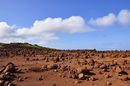
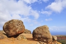
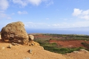
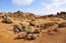
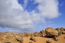
Garden of the Gods |
|
|
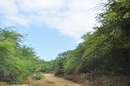
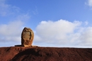
Take Highway 440 North out of Lanai City. You will pass the Lodge at Koele. A rock sign (top picture on this page) on the right side of the road points toward the Garden. Turn left here on Polihua Road between the tennis courts and the horse stables. Past the stables the road becomes dirt. Turn right at the next large "intersection" and continue north-west to the site.
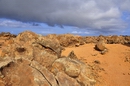
Ancient Hawaiian legend states that the rocks and boulders here were dropped from the sky by the gods tending their gardens. Hence the name, Garden of the Gods. These beautiful and unique rock formations were formed by thousands of years of erosion creating pinnacles and buttes in a remote canyon area. Colors of red, purple, and ochra earth and crusted lava create a striking lunar landscape.
This area is especially beautiful at dawn and dusk. DO NOT, however, try to travel these roads in the dark. The dirt road is pocked with ruts and rocks. Only 4-wheel drive vehicles should attempt this trip. It leads all the way to Ka'ena Point and Polihua Beach. |
|
| Lanai, Hawaii |
|
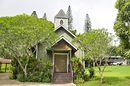
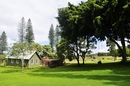
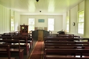
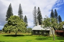
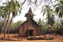
Kalokahi o Ka Malamalamo Church |
 |
|
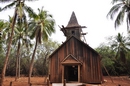
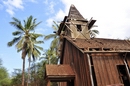
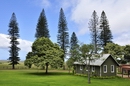
Go north out of Lanai City on Highway 44. The church is located in front of and to the left of the Lodge at Koele Resort.
This quaint little wooden church church was built during the Plantation Days of the late 1800's and early 1900's as a place for Hawaiian religious services. It is a reminder of a very different life when Lanai City was a bustling Plantation Town. Today the church still holds Sunday services spoken in Hawaiian.
|
|
| Lanai, Hawaii |
|
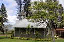
Ka Lanakila o Ka Malamalama Church |
|
|
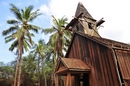
Take Keomuku Road or route 430. Keomuku is located on the east shore of Lanai. During ancient times, fishermen and farmers settled along the coastal portions of this area up to the valley of Maunalei. Keomuku was a small and sleepy fishing village up until 1899, when the Maunalei Sugar Company moved in, turning the village into a bustling sugar plantation. It was shut down in 1901. According to a local legend, they built the railroad along the coast, damaging the sacred stones of a nearby heiau (Hawaiian temple). The Hawaiians believed that this angered the gods and that this is the reason why the sugar mill’s drinking water turned salty and the population was wiped out by an epidemic. Today, Keomuku lies abandoned and is called a ghost town by some. Little remains of the village and there is little evidence that once a thriving sugar industry was located here. The only structures that are left standing are a few old wooden houses and the original structure of the Ka Lanakila o Ka Malamalama Church, which was completed in 1903. It is the last structure that is still intact in the village. |
|
| Lanai, Hawaii |
|
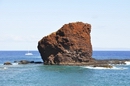
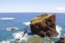
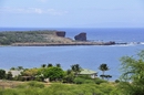
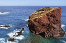
Pu'u Pehe Tomb (Kupapau Puupehe) |
 |
|
Take Highway 440 south from Lanai City approximately 13 miles. Follow the signs to the Hulopo'e Beach Park. Take the trail to the left of the beach to the overlook.
The real name for this unusual structure atop Pu'u Pehe Rock is Kupapau Puupehe meaning "owl trap hill". The rock structure is a platform 6 feet wide, 21 feet long, and 3 feet high. On top of the platform and slightly north of center, is a stone 8 inches square and about 18 inches high set in an upright position. Archeologists found no human remains anywhere on top of the rock but many bird bones, mainly terns, and egg shells. They surmise the platform was a shrine used by bird hunters during ancient times. |
|
| Lanai, Hawaii |
|
Halulu Heiau |
| |
|
Take Highway 440 west out of Lanai City toward Kaumalapau Harbor. Go past the airport turnoff and take the next left Kaupili Road, an unmarked dirt road. Travel approximately 2.5 miles to a yellow standpipe on the right. Turn right on this rocky road which descends downhill about 3 miles to Kaunolu Village. The intrepretive hike is on the right and will point out the heiau which is located across a small stream that runs through the gulch. Accessible only by a 4-wheel drive vehicle during dry weather. This is an ancient, religious site - be respectful!
This well-preserved heiau is located across a wide gulch in the ancient fishing village of Kaunolu. After King Kamehameha the Great captured the island of Lanai in the early 1800's, he used this village as his favorite vacation spot due to the excellent fishing it provided. King Kamehameha also rebuilt the old heiau that was on this site and declared it a luakini heiau or place of refuge. A place of refuge meant that anyone who broke one of the laws would be forgiven if he made it to the place of refuge before he was caught. |
|
| Lanai, Hawaii |
|
King Kamehameha the Great's House |
| |
|
Take Highway 440 west out of Lanai City toward Kaumalapau Harbor. Go past the airport turnoff and take the next left Kaupili Road, an unmarked dirt road. Travel approximately 2.5 miles to a yellow standpipe on the right. Turn right on this rocky road which descends downhill about 3 miles to Kaunolu Village. The intrepretive hike is on the right and will point out the residence.
This rock structure was once the large vacation home of King Kamehameha the Great. After conquering Lanai in the early 1800's in his quest to unite all the Hawaiian islands, Kamehameha rebuilt the village of Kaunolu located on Kaunolu Bay. |
|
| Lanai, Hawaii |
|
Luahiwa Petroglyphs |
| |
|
The site of the petroglyphs is not marked. Ask for clear directions and road conditions before starting out. Take Highway 440 south from Lanai City. After the guard rail on the road ends turn left on a gravel road that soon becomes a dirt road. There is a large water tower on the hill above the basin. To the right of the tower is a wide gulch. To the right of the gulch is a stand of trees. The petroglyph boulders are located down the slope from the trees.
Ancient Hawaiians came to Lanai as early at the 15th Century. Petroglyphs are drawings made on lava rocks by these early settlers. Luahiwa Petroglyphs has one of the most exciting and interesting collections of such ancient writings in all of Hawaii. |
|
| Lanai, Hawaii |
|
Kahekili's Leap |
| |
|
From Lanai City, take Highway 440 west toward Kaumalapau Harbor. Past the airport turnoff, turn left onto Kaupili Road, which is an unmarked dirt road. After about 2.5 miles (4 km), you’ll see a yellow water pipe on the right. Make a right turn here. This road goes downhill and leads to Kaunolu and Kahekili's Leap after about 3 miles (4.8 km).
Kahekili's Leap is a rock ledge on Lanai's south shore. It was here where King Kamehameha's warriors proved their bravery by leaping 80 feet (24 m) into the ocean below. This is a steep rock face, but what adds to the challenge is the fact that the rocks at the base extend about 15 feet (4.5 m) outwards and the water is only about 10-20 feet (3-6 m) deep and the ocean bottom rocky. |
|
| Lanai, Hawaii |
|
Kaunolu Ancient Village |
| |
|
Take Highway 440 west out of Lanai City toward Kaumalapau Harbor. Go past the airport turnoff and take the next left Kaupili Road, an unmarked dirt road. Travel approximately 2.5 miles to a yellow standpipe on the right. Turn right on this rocky road which descends downhill about 3 miles to Kaunolu Village. The intrepretive hike is on the right.
This ancient Hawaiian fishing village was thought to be first inhabited in the 15th Century. It was once the vacation site of King Kamehameha the Great. After he conquered Lanai in the early 1800's, he selected this site as a favorite fishing spot. He rebuilt the Halulu Heiau and had a residence nearby. People lived in this village until the late 1800's. It is thought to be the religious center of Lanai. |
|
| Lanai, Hawaii |
|
Federation Camp |
| |
|
Take Highway 44, Keomuku Road, northeast out of the City of Lanai. Go to the end of the road which is approximately 7 miles from town. Turn left on the dirt road going toward Shipwreck Beach. Federation Camp is located about 1/4 mile down the road on the right.
This fishing camp was built entirely from driftwood and lumber that washed ashore on Shipwreck Beach nearby. Built in the early 1930's by Filipino fisherman, this camp is still used by locals during their fishing outtings. Several houses, picnic tables, and a latrine are scattered around the area making up the Federation Camp. The area is kept in good repair considering all the building materiel is litterly scrap lumber. |
|
|